Council has a duty of care to manage lands subject to flooding within its Local Government Area, under the NSW Government's Flood Prone Land Policy. Council is responsible for formulating and implementing Floodplain Risk Management Plans in accordance with the policy.
The main objective of Floodplain Risk Management is to reduce the impact of flooding and flood liability on owners and occupiers of flood-prone property and reduce public and private losses.
Floodplain Risk management is a four stage process:
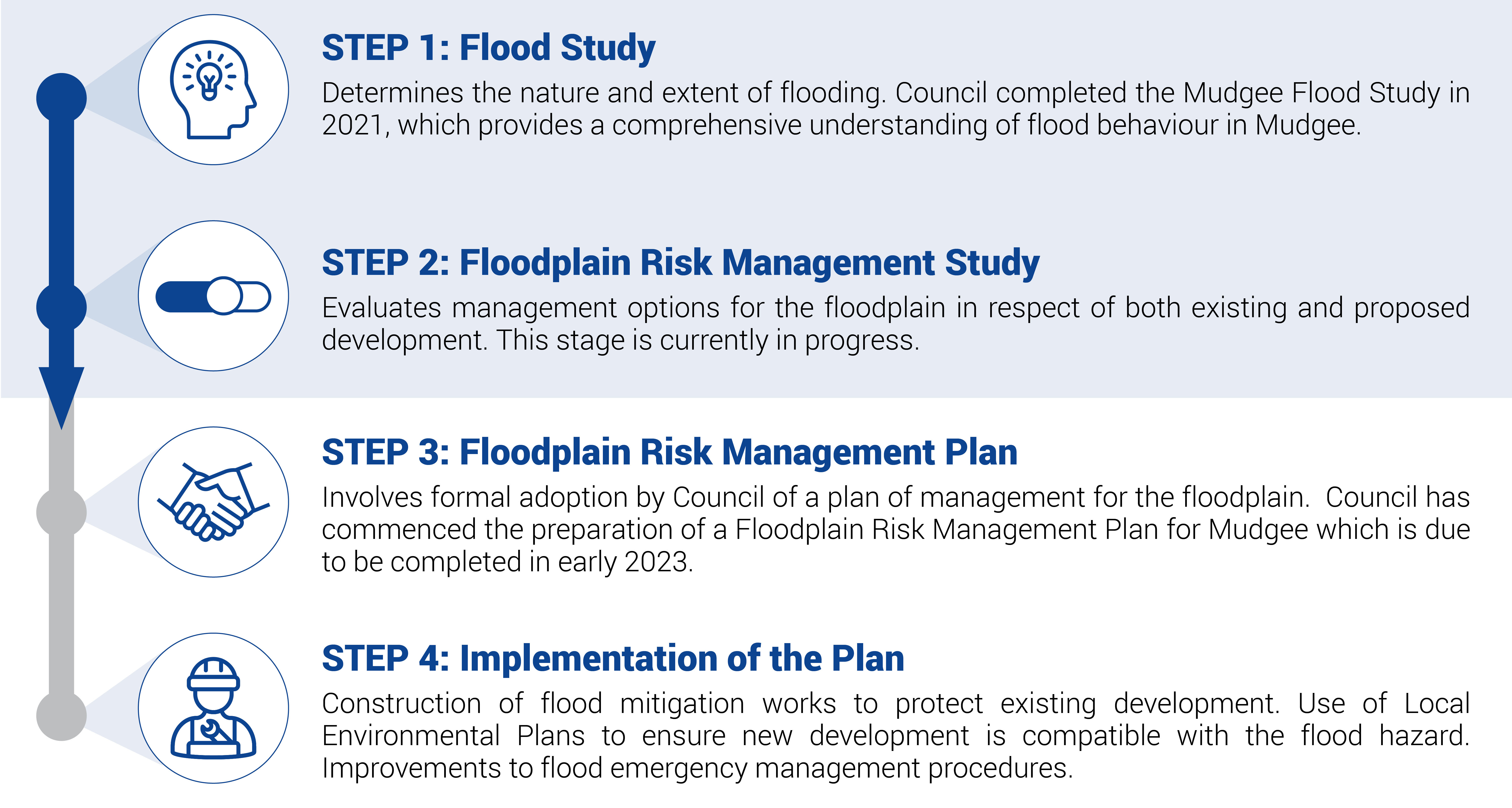
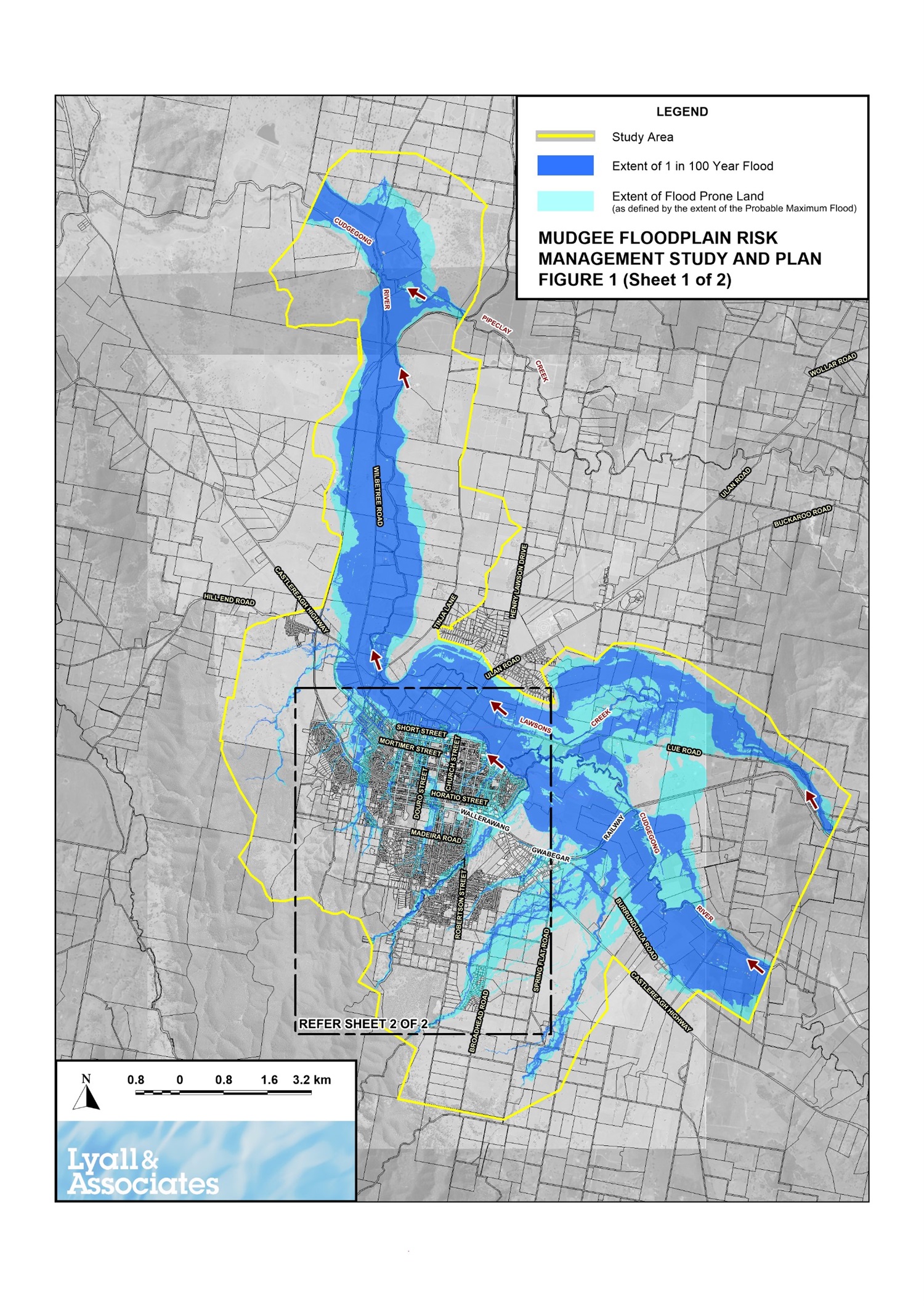
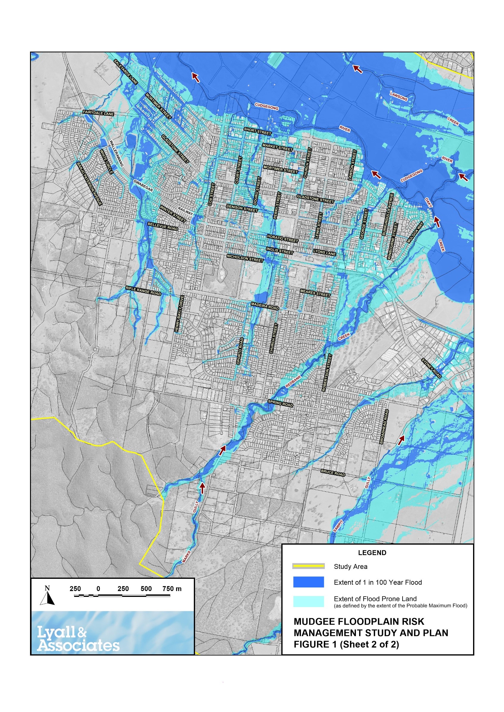
In 2021, Council adopted a Mudgee Township and Surrounds Flood Study to assess flood risk in accordance with the key controls of Probable Maximum Flood level for riverine flooding and overland flow; and update the existing Flood Planning Area (FPA) to incorporate the new information. This completes Stage 1 of the management planning noted above.
Mudgee Flood Study 2021(PDF, 20MB)
Probable Maximum Flood level is the largest flood that could conceivably occur at a particular location, usually estimated from probable maximum precipitation coupled with the worst flood producing catchment conditions. Overland flow is generally caused by run-off from short and intense rainfall and can result in inundation of properties.
Previously a 1:100 year flood level was assumed in flood modelling. The NSW Government's Floodplain Development Manual (2005) outlines that the Probable Maximum Flood level and overland flow should be identified in all flood studies conducted by Councils.
The study identified some areas of the Mudgee township as having some risk of flooding, not necessarily a high likelihood.
To inform Stages 2 and 3 of the management planning, affected residents have been contacted by mail and are encouraged to provide their feedback through a hard copy and/or online survey. This feedback is valuable as it will contribute towards the risk management planning that will inform future flood mitigation measures, planning of development, emergency management and community awareness in relation to overland flooding.
Residents are encouraged to contact Council directly should they have any concerns or would like further detailed information about their property.
FAQS
What is probable maximum flood level?
The Probable Maximum Flood level (PMF) is the largest flood that could conceivably occur at a particular location, usually estimated from probable maximum precipitation coupled with the worst flood producing catchment conditions. The Probable Maximum Flood defines the extent of flood prone land (i.e. the floodplain). The extent, nature and potential consequences of flooding associated with events up to and including the Probable Maximum Flood are addressed in a floodplain risk management study.
The presence of the PMF flood level on a section 10.7 certificate is to ensure that in the event of the potential development of a site the owner is aware there may be some additional conditions required depending on the type of development proposed. It should be noted that the PMF flood level is only used to set the floor level of Critical Facilities. In all other development scenarios the Flood Planning Level (which defines the minimum building floor level) is set to the 1% AEP + freeboard or lower, as per the approach that has been applied in the region over the past decade.
What is overland flow?
Overland flow is generally caused by run-off from short and intense rainfall and can result in inundation of properties. Under NSW Government requirements, Councils must manage this risk through building works and development controls which help to ensure new development is protected from potential damage, and overland flow paths aren't impeded or redirected onto surrounding properties.
Overland flow paths comprise all land subject to overland flow during and immediately after a heavy rainfall event as water makes its way through the catchment to the watercourse.
Will a notation cause my insurance premium to rise? Do I need to tell my insurance company?
If you are concerned, contact your insurer directly to find out how it classifies flooding (and storm water), and how this relates to your insurance provisions and premiums.
Insurance companies use a variety of sources to calculate risks and premiums, including the National Flood Information Database, which is funded by insurance companies through the Insurance Council. The insurance industry also uses its own estimates for flood risk assessment and its own definitions for flooding. These may differ from Council’s information. When requested, and where required, Council supplies flood information to the insurance industry.
Can I request a review?
Council uses up-to-date flood modelling techniques, as well as expert assistance from consultants and the NSW Government, to determine mapping and assessments. We believe our flood level estimates are as accurate as possible.
If you believe the assessment is not correct for your property, you can write to Council to request a review. Your request must specify why you disagree with our assessment and provide as much information as possible to support your claim; such as survey levels for the review. Alternatively, you can seek professional advice relating to your property.
What is Council’s responsibility?
Communities need to be prepared for flooding, understand how to respond to flood threats and recover from the impacts of floods. The impacts of floods and damage to property can be avoided by taking action before the event occurs. In this regard, Council has two key responsibilities:
- Keeping the community informed about flooding, educating the community around flooding risk, support emergency management planning, and examine options to manage flood risk.
- Take flooding into account when controlling the development of flood-prone land, and in carrying out management actions including the investigation, design, construction, operation and maintenance of flood mitigation works.
How does this affect my property?
The presence of your property within the FPA only affects you if you wish to undertake development on the property or sell your property.
Council has a responsibility to inform the community and future property owners about potential risks to life and property, and to help limit damage from flooding now and in the future, and about development controls that may apply to specific property. Any property identified as being flood prone and that may attract development controls will have a flood notation on its Section 10.7 Certificate (formerly Section 149 Certificate).
If you do not wish to sell or develop your property, no action is required however it is recommended you take the time to understand the risk posed to the property.
If you do wish to build on your property the presence in the FPA enables Council to provide controls to help protect property owners, residents and to minimise future property damage. It is unlikely that development controls will prohibit all development on land on flood prone land. However, some factors may need to be taken into consideration in any future development to alleviate risk to life and property. For example, you may be asked to build on a certain part of your land or elevate your building to a certain height or, in some locations, build to higher building standards. Council’s development assessment team can help you understand these considerations.
If you wish to sell your property, from the Section 10.7 Certificate, potential buyers will be aware of this flood risk and controls which may apply. Council recommends you discuss with your Real Estate Agent what information you need to provide the Agent in preparation for the sale.
More information is available via the Flood Study 2021(PDF, 20MB) . Alternatively, if you require site specific information and mapping please contact Council on 6378 2850 and ask to speak with a development engineer or email council@midwestern.nsw.gov.au.
Council provides all information it holds in relation to flooding in “good faith” and is protected by the provisions of s.733 of the Local Government Act from any liability that it may incur as a result of that information
Mapping of Affected areas